Greenwood's Historic Power Building
BY: BG EDITOR
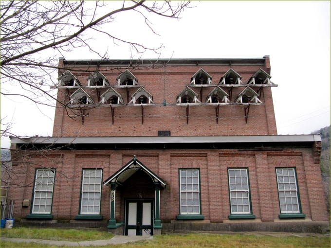
The West Kootenay Power Building - Greenwood, B.C.
[ Photo: BeautifulGreenwood.com ]
Oct 29, 2016 — GREENWOOD, BC (BG)
One of the most unique heritage buildings in Greenwood is the West Kootenay Power Building, which is situated on Highway 3 at the south end of the city. The building has numerous small roofed structures that catch the eye of passersby. Reminiscent of large birdhouses, the roofed areas were designed to protect the electric system's insulators.
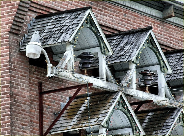
Power Building 'Birdhouses' sheltering insulators
[ Photo: Waymarking.com ]
Built in 1905-06, this distinctive brick building was constructed to serve as a power substation for the West Kootenay Power Company, who maintained offices in the building until 1997. The Power Building was later sold to the City of Greenwood, who now manages the heritage site along with the Board of Trade and the Greenwood Community Association.
The West Kootenay Power Building was constructed in Greenwood to serve the local community and mining operations in the area. But it is also part of a 'larger picture', that encompasses both regional power generation and fresh water systems.
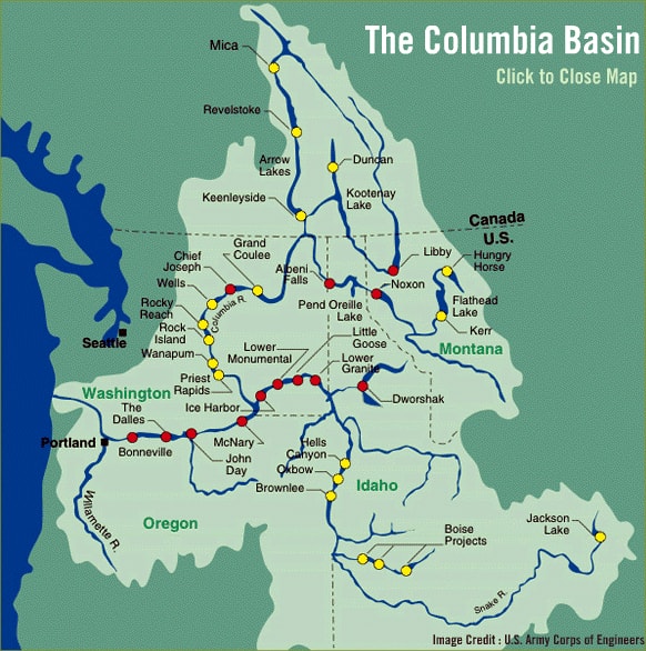
The Columbia Basin
[ Photo: US Army Corps of Engineers ]
Greenwood is located within the Columbia Basin -- a system of lakes and rivers connected to the Columbia River, which is the largest river in the Pacific Northwest. Rising out of the Rocky Mountains in B.C., the Columbia River flows northwest and also south, into Washington State. Greenwood is situated on the western-most edge of the Columbia Basin system, which is divided into seven regions. Our is Region Seven.
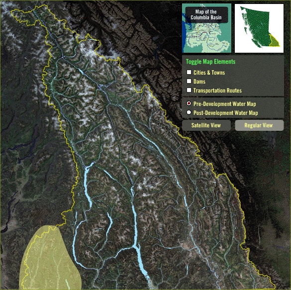
Regional map of the Columbia Basin
Region Seven is the shaded area, bottom left
[ Photo: VirtualMuseum.ca ]
Region Seven, 'The Boundary', includes the communities of Greenwood, Phoenix, Cascade, Grand Forks, and Christina Lake. Within its borders are four water bodies: the Boundary Creek, Kettle River, Granby River, and Cascade Falls. There are also three historic dams in the region: Boundary Falls Dam (c. 1898), the Cascade Dam (1899), and the Granby Dam (1899).[1]
Cascade City[2] was located 1 km. north of the Canada/U.S. border, just 6 km. south of Christina Lake, and 20 km. east of Grand Forks.
The West Kootenay Power Building in Greenwood delivered electricity that was being generated from the Columbia Basin waters. The history of the power industry in the Kootenay/Boundary region has been the subject of a number of books. But one of the earliest mentions we find is in Fruit Ranching in British Columbia by J.T. Bealby, M.A., published in 1909[3]. Describing his farm and orchard operation at the top of the Kootenay River, he writes:
"Both the Upper and the Lower Falls in the [Kootenay] river had been harnessed and made subservient to the needs of man. At each fall the West Kootenay Power and Light Company had constructed an electric plant, for the purpose of supplying electric power to the mines and smelters at Rossland, Trail, Phoenix, Greenwood, and other towns along the American-Canadian frontier line, twenty to fifty miles distant."
The author refers here to the Kootenay River falls:
"To say that the company had constructed its plant at both falls is not quite accurate. The works at the Lower Falls were, indeed, completed; but they had been discarded in favour of a more up-to-date and more powerful equipment at the Upper Falls, and this latter was not yet fully completed. Seventy men were still at work putting the finishing touches to the constructional works, although the plant was running and supplying power."
What later became the West Kootenay Power & Light Company was originally the B.C. Construction and Distributing Company. The entire smelter and Motherlode Mine were powered by electrical energy they generated at Bonnington Falls. In 1897, the Company started up an 1,800-kW plant on the Lower Bonnington River, to serve the smelter at Trail, B.C. In 1899, they doubled the generating capacity at this plant to keep up with the growing mining industry. In 1901, they installed a 2,610-kW plant at Kettle River, and began to serve mines in the Greenwood and Cascade areas, and the local communities growing up around them. By 1907, the company was firing up a 12,000-kW hydroelectric plant on the Upper Bonnington to meet the growing demands of the mining industry.[4]
For the City of Greenwood and its mining operations, power generation relied not only on the Kootenay River falls project, but also on the Boundary Falls Dam, operated by the Greenwood Water, Power & Light Company. Known as 'run of the river' energy generation, the historic Boundary Falls Dam project is described in the Virtual Museum[5]:
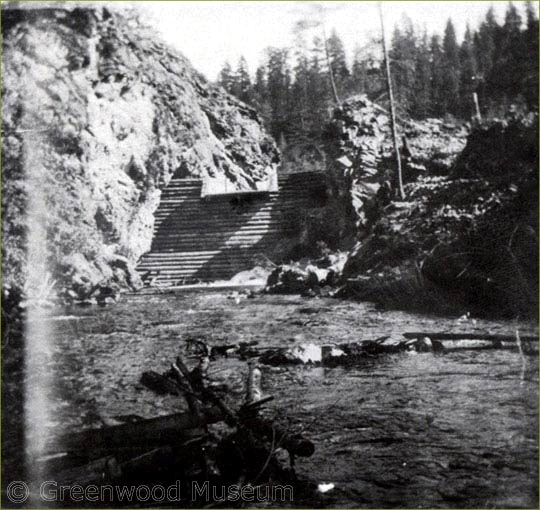
Boundary Falls Dam, looking downstream, 1901
[ Photo: Greenwood Museum & Archive ]
"Boundary Falls is located on Boundary Creek, about 3 miles south of the City of Greenwood it was the site of one of the first power dams in the Boundary region. At the turn of the 20th Century, the town of Boundary Falls had a population of several hundred and a full supply of hotels, stores, a post office and school and a hydro power plant to supply the Dominion Copper Company Smelter. Today, Boundary Falls consists of a small cluster of buildings along the side of the highway.
Construction on the dam began in 1898, to provide power to the towns of Boundary Falls, Greenwood and some nearby mines.
The dam was built of concrete and wood 40 feet (12 metres) long and 60 feet (18 metres) high. It was constructed upstream from Boundary Falls and the water was carried to the powerhouse by a steel riveted pipe 1300 feet long creating a hydraulic head of 130 feet. The water flume was blasted out of the side of the cliff surrounding the Falls on the east side of the creek (with a walkway beside it for inspection purposes) and then connected to the turbines within the powerhouse.
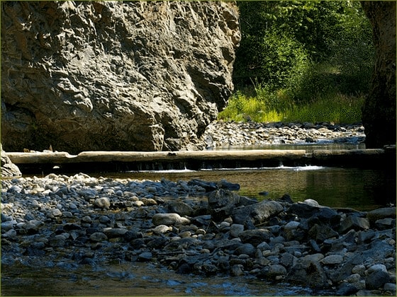
Boundary Falls Dam
The last logs of what was once a 60 foot high log and earth dam
on Boundary Creek in 1898
[ Photo: Henry Caron, DPReview.com ]
The roar of the water coming through the flume was immense. The power plant was constructed of cement blocks with high ceilings were the office, the generator, turbine and a cot for use by the night shift.
In 1919 the power plant was being phased out as it had problems with low water levels in the winter and was eventually shut down in the summer of 1920 when water levels were too low to turn the turbines. West Kootenay Power and Light began to supply power to the City of Greenwood after that as well as the other customers this small dam had serviced for almost 20 years.
The foundations of the dam and some of the walkway infrastructure clinging to the side of the cliff are all that remain of this pioneer dam."
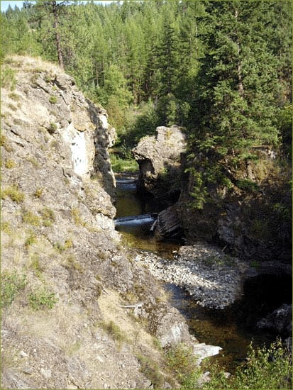
The remnants of the Boundary Falls dam
visible at the creek bottom, near the large rock outcrop
[ Photo: Virtual Museum.ca ]
Greenwood's Power Building is adjacent to the Trans Canada Trail, and sits at the foot of a ridge of slag, with the Hell's Bells visible from the building lot. On the hill behind it, the original cutline for power poles running between the substation and the Kootenay River dams is still visible.
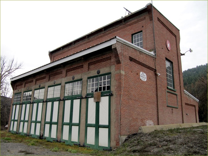
Power Building loading doors
[ Photo: BeautifulGreenwood.com ]
On one long side of the building is a row of green and white loading doors. At one time, a rail line delivered cars right to these substation doors, to facilitate loading of heavy transformers.
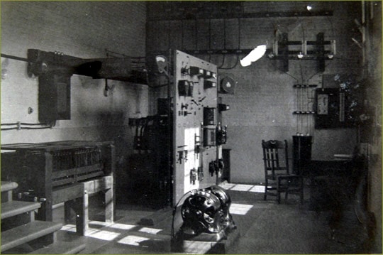
Interior of the West Kootenay Power Building
[ Photo: Rossland Museum ]
The interior of Greenwood's Power Building is as interesting as the exterior, although less often seen. Transmission lines carried electricity into the substation, where it was controlled and monitored with various breakers and gauges. Today there are two generations of electrical equipment on site: original gear, and a modern installation of solar panels and controls.
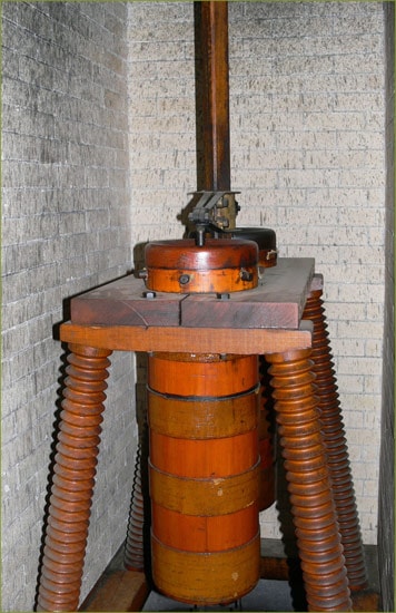
An oil-filled wood insulator used in the Greenwood substation until the early 1980's
[ Photo: Rossland Museum ]
FOOTNOTES:
[3] Fruit Ranching in British Columbia by J.T. Bealby, M.A., Chapter VI (1909)