The Boundary: Garden of Canada
BY: BG EDITOR
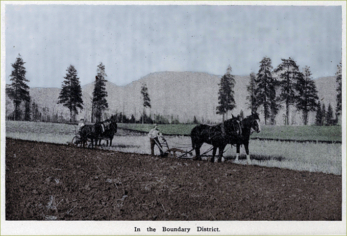
Illustration from THE BOUNDARY — Southern British Columbia: The Garden of Canada
May 04, 2019 — GREENWOOD, BC (BG)
Today we bring you an interesting description of the Boundary region written in 1909, for inclusion in the book, The Boundary, which details the resources and climate of the Kootenay, Boundary and Okanagan Districts, and the 'Far-Famed Columbia Valley'. Among the chief towns of the Boundary are Greenwood, Grand Forks, Midway, Eholt and Phoenix.
THE BOUNDARY
Southern British Columbia: The Garden of Canada
West of the Kootenays lies the Boundary country, which forms the extreme southern part of Yale District. It is about 40 miles from east to west and extends for 50 miles north from the International boundary. The character of the district, ' while varied, is not very different from that of other parts of the great interior plateau of British Columbia, save that the highest elevations seldom exceed 5,000 feet. Most of the hills are wooded to their summits, with open slopes, facing south, east and west, plentifully carpeted with bunch grass, a natural beef producer, while the valleys offer excellent openings for farming and fruit growing, the higher benches requiring irrigation. The climate is mild and healthful, presenting no extremes of heat or cold. The snowfall in the valleys is light and spring opens early. The winter is confined to eight or ten weeks of frosty weather, the mercury occasionally falling below zero, but the cold is not extreme nor protracted. The summers, like those of the Kootenays, are warm without being oppressive, and the nights are always cool. The atmosphere is clear, the prevailing condition being bright sunshine both winter and summer, and the air is crisp, dry and bracing. The average rainfall is 10.8 inches, and snowfall 27 inches which would represent seven to twelve inches on the level.
Between Lower Arrow Lake, its eastern boundary, and the divide between the Kettle River Valley and Okanagan Lake, the Boundary possesses many fertile valleys and wide stretches of rolling prairie, all more or less wooded. The beautiful Kettle River Valley includes from 40,000 to 50,000 acres of farming lands, a rich black loam averaging 18 inches, with a sandy clay subsoil, while lesser areas are situated on Boundary Creek, Anarchist Mountain, or Sidley, Rock Creek and on the North and West Forks of the Kettle River. All the soil of these valleys and their benches is alike fertile and capable of producing grain, fruits and vegetables, even in the higher altitudes, as at Anarchist Mountain 3,500 feet altitude, where hardy grains and vegetables do excellently and yield heavy crops. This should be proof positive of the fertility of the soil. The abundance of water and the variety of the native grasses makes the Sidley Section an ideal dairy country. Hogs and poultry raising have proved very profitable to those who have tried them. Most of the land not already taken up is in the railway belt. One of the unique conditions found in this section is, that despite its high altitude neither drainage or irrigation is required.
There is a fine plot of land near Midway, which the settlers testify is free from summer frosts and yields splendid crops of potatoes, barley, oats and vegetables. Fruit is successfully grown although the number of trees planted as yet is not large. Those that have come into bearing show a healthy, clean growth, and produce goods crops. A peculiar fact was noted near Midway by Professor Sharpe of the Government Experimental Farm at Agassiz, B.C., which is, that "potatoes and fruit trees on the uplands north of the town were doing very well without irrigation." Other observers have made similar remarks with regard to other parts of the southern districts, and there is little doubt that some of the bench lands, of exceptional depth and fertility, will yield good returns for many years without irrigation if extra care be given in the way of tillage and rotation of crops.
Between Cascade and Carson, 12 miles, there is a fine tract of land, about 20,000 acres, in a beautiful valley about two miles wide. Most of the cultivated land here is devoted to mixed farming and dairying. Fruit growing is rapidly becoming popular in this section, about 30,000 trees representing the progress made so far. The land is admirably adapted to apples, pears, plums and berries; cherries, grapes and peaches are also grown to a small extent. Five carloads of fruit were shipped in 1905 to eastern points.
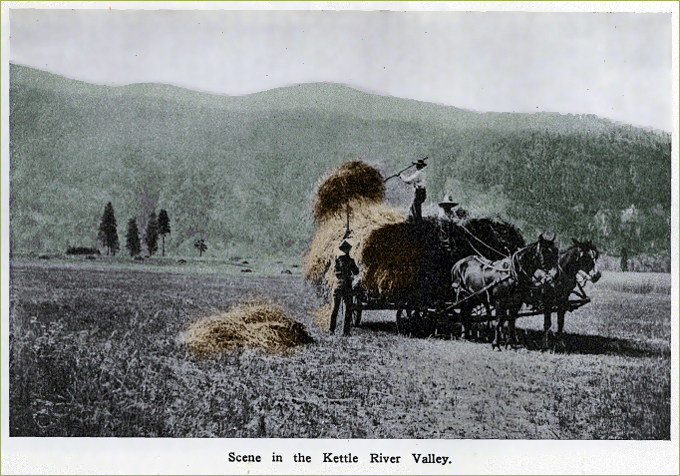
Illustration from THE BOUNDARY — Southern British Columbia: The Garden of Canada
A BRIGHT FUTURE
Three lines of railway are now projected traversing the Boundary so that its future as a desirable field for agriculture and other industries is assured. Even now, with transportation facilities confined to a comparatively small portion of the district, the farmers are thriving and steadily growing rich. The numerous mining camps scattered over the countryside, the logging camps, lumber mills, and smelters, provide markets at the very farm gate, indeed, it is almost a rule for the buyer to seek the market, thus reversing the order prevailing in older countries, and the prices are, to say the least, satisfactory, for instance, oats range from $30.00 per ton; potatoes. $20.00; hay, $25.00; beef cattle, 3½ to 4 cents per pound, live weight; hogs, live weight, 7 cents; eggs average 30 cents; butter, 25 to 30 cents per pound.
The Boundary, and in fact all Southern British Columbia, offers exceptional opportunities to industrious, steady men of small means. Mechanics, laborers and miners are in demand at good wages, while the practical farmer can make no mistake in securing land and devoting himself to its cultivation.
The Covert Ranch, near Grand Forks, is a splendid illustration of what may be accomplished by any man possessed of energy and perseverance. The owner of this magnificent property began life in the Boundary with a pair of willing hands and a cash capital of $60.00, borrowed money. To-day he owns one of the most valuable properties in the province and has been for many years living in the midst of plenty — master of a competency.
CHIEF TOWNS OF THE BOUNDARY
GRAND FORKS, situated at the junction of the Main Kettle River with its North Fork, is the centre of a beautifully picturesque valley, twenty miles long with an average width of three miles containing an area of 20,000 acres of fruit land. As a fruit country, the district adjacent to the city is unsurpassed. In 1907 Grand Forks won the district exhibit cups at Nelson and Kaslo, a bronze Knightian Medal at the London, Eng., Exhibition and the Gold Medal for the best five boxes of commercial apples at the Northwest Fruit Growers' Exhibition, held in Vancouver, in a competition with the famous Oregon and Washington apples.
The chief industries established are the Granby Smelter, second in size on the continent, treating over 24,000 tons of ore each week; a steel works, and Iron foundry, a saw mill, a sash and door factory, two breweries, a bottling works, a brick yard, a lime kiln and the Riverside Nursery. Grand Forks has a public and high school with a staff of nine teachers. A few years ago Grand Forks was a mining camp; to-day, besides being a home of the second largest smelter on the continent, it is the centre of one of the richest fruit areas in. the interior.
GREENWOOD, a prosperous mining town, situated at the junction of Twin Creek with Boundary Creek, 117 miles west of Nelson on the Columbia and Western Branch of the Canadian Pacific Railway, is one of the most important commercial and mining centres of the Great Boundary District.
Roads radiate from the town in all directions, giving access to the numerous mining camps, where it derives the greater part of its trade. The British Columbia Copper Company's smelter, situated at Anaconda, a suburb of Greenwood, has a capacity of over 2,000 tons per day. The Mother Lode Mine, from which the greater part of the ore is received, is situated about three miles from the town and employs several hundred men. The Greenwood-Phoenix Tramway Company have started in active operation for their big tunnel which will bore the hill between Greenwood and Phoenix, a distance of over three miles. This will tap several of the high grade mines in the district at a depth varying from 1,000 to 3,000 feet, the success of this tunnel will mean the opening up of several new properties in the surrounding camps. Adjacent to Greenwood on Boundary Creek are numerous ranches which have made a success in fruit raising which meets with a ready sale in the town, a conservative estimate has placed the timber resources in the immediate neighborhood at several hundred million feet.
Greenwood is lighted by electricity generated from the Falls on Boundary Creek, about three miles and a half south of the town. Its water supply is ample for all purposes and is unexcelled for its purity. There are several churches, good schools, numerous hotels, three chartered banks, and several wholesale and retail stores, and a newspaper.
PHOENIX, five miles east of Greenwood, on a branch of the Canadian Pacific Railway, occupies the highest position of any incorporated city in Canada, being at an altitude of 4,694 feet above sea level, but that does not constitute its only attraction. The proximity of the Granby Mines, Old Ironsides and the Knob Hill Group, and many others, containing immense ore bodies, give Phoenix a special importance. These mines have produced over 2,000,000 tons of ore valued at about $10,- 000,000, and are to-day shipping more ore daily than ever before. Phoenix has five churches, a public school, hospital, also several good hotels and stores. The streets are well graded, the town is electrically lighted and has a good water supply.
EHOLT, a divisional point on the Columbia and Western branch of the Canadian Pacific Railway, is ten mites from Phoenix, and is the centre and supply depot for Long Lake, Summit and other mining camps. Besides the Canadian Pacific Railway shops and roundhouses, a number of local business houses and minor industries add to the wellbeing of the town.
MIDWAY, nine miles southwest of Greenwood on the Kettle River, is the present Western terminus of the Columbia and Western Railway, which the Canadian Pacific Railway intends to extend westward to tap the Okanagan Lake country. The town, though small, seems destined to become an important place, as it is surrounded by a splendid farming and mining country and promises to be a railway centre. There are several other towns of more or less importance in the Boundary District, of which may be mentioned Boundary Falls, the site of a large smelter; Cascade City, at the southern end of Christina Lake, a beautiful body of water is the site of the Water Power and Light Company's plant, which supplies power to the Boundary mines and smelters, and Camp McKinney, a mining town.
ALTITUDES
For purposes of comparison we give below the altitudes of some of the places to which reference is made in this pamphlet. They are :—
Name — Feet
Anarchist Mountain, West Kootenay — 3>500
Creston, East Kootenay — (about) 1,800
Grand Forks, West Kootenay — l,750
Greenwood, West Kootenay — 2,400
Midway, West Kootenay — 1,850
Moyie, East Kootenay — 2,997
Okanagan (District), West Kootenay — 1,150 to 1,500
Tobacco Plains (in Kootenay River Valley), East Kootenay — 2,300
Windermere District — 2,500